HEC-RAS Cross Sections
HEC-RAS application is a very powerful application where it can do a number of analysis of hydraulic and hydrology especially in river. It can use to create modeling system goes under one dimensional steady flow, unsteady flow calculations, sediment transport/mobile bed computations and water temperature modeling. Besides, most important is it is FREE software. As a result, it will attract a lot of users to use it.
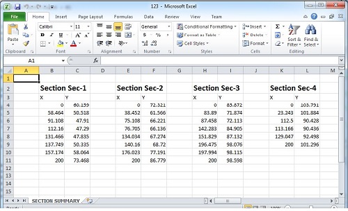
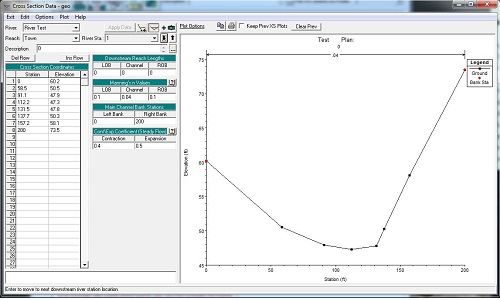
In the river hydraulics works, it will involve on preparing cross sections. One of daunting issue is the time on preparing cross section. Whenever engineer needs to study a site, normally engineer will requests ground data such as require land surveyor to go to site to take some measurements. Important information will be the levels of site. Land surveyor will compiles the result tentatively presented in drawing in dwg format. Or provide a raw data of coordinates in plain text format etc. One of the limitation of HEC-RAS, it cannot operate with dwg drawing. As a result, once the data given in drawing, engineer will need a substantial of time to extract data such as cross section or profile from drawing. Basically, engineer will marks out location of river, demark location of cross sections. Then engineer will extract one by one either direct manually from printed drawing or use any CAD software to measure out. Both ways will needs a lot of time to do it. Engineer needs to measure coordinate by coordinate, and then capture corresponding Z value or elevation of coordinate. After those coordinates, engineer begins to transfer into HEC-RAC cross section input. He has to go through River station by station, enter require coordinate in Cross Section Coordinates table. Do imagine that if there are a number of sections to be generated, this can be a nightmare for him. With our Zeon Viewer, we have a feature of extracting cross section profile from digital drawing of land surveyor. In which it is a handy method to do it. It does not requires very expect person to handle it. It just need a CAD operator will do. What it needs is some basic information about CAD, such as Text entities of surveyor data in layers; then the location of cross sections. All these works can be done by CAD operator such as draft person.
Steps
- First step in our Zeon Viewer will be identify text entities of land surveyor data in layer names.
- Second step will be extracting these data in Zeon Viewer.
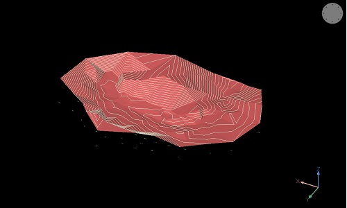
- Third step is to generate 3D terrain.
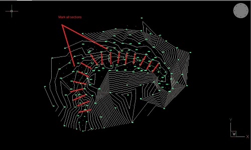
- Fourth step is to demark location of cross sections in CAD drawings.
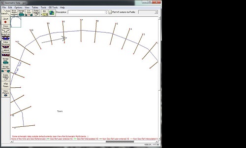
- Fifth step is to generate cross sections.
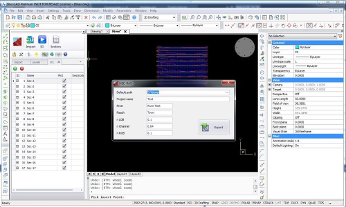
- Finally step is to export cross sections coordinates directly to HEC-RAS, text file or excel file.
Those who interestd more on this can send email to zeonsupport@civilstructural.com.my to request more info on this